Posts

Showing posts with the label Penang Hiking Trails

Moon Gate to Station 5 Rest Area via Wild Boar Trails

Image
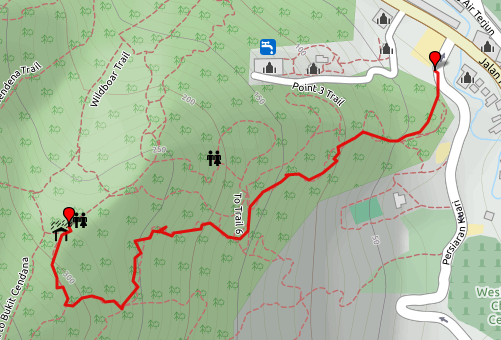
These are the alternative trails from the usual staircase trail that most Penang hikers would use. Local Penang hikers called the trails "Wild Boar Trails". As you can see from the map, the trails have a few branches but all of the trails will eventually ends at the Station 5 rest area. Below are a few Wild Boar Trails I have tracked during my weekly hiking routine. This hiking trail starts from the  Moon gate  entrance and ends at  station 5 rest area . This trail will take you through a series challenging slopes. There are many areas that have ropes tied from tree trunk to tree trunk for hikers to hold on while scaling the slopes. Please wear a good hiking shoes to have a better grip on the dirt while hiking. Wild Boar Trail #1 Trail Map Elevation Profile Trail Details Distance : 1.358km Max Altitude : 296m Elevation Gain : 241m Estimated Hiking Duration : 41 minutes Download GPX file Wild Boar Trail #2 Trail Map Elevation Profile Trail Details Distance : 1.316km Max Al...

Bukit Cendana Hiking Trail

Image
Penang Hiking Trails : Bukit (hill) Cendana Peak via Cendana Trail and back to Moongate via Station 5 rest area. Elevation Profile Hiking Trail Details: Distance : 4.584km Elevation Gain : 542m Estimated Duration : 3 hrs Download GPX file

Moongate to 84 via pondan trek and Cendana hill

Image
Penang Hiking Trails : From Moongate to 84 via Bukit (hill) Cendana peak This hiking trail is one of the toughest hiking trails from Moongate to 84 rest area. Be well prepared for this hiking trail. However, you don't have to bring plenty of water with you as you can get refreshment from point 5 rest area midway through. Elevation Profile: Hiking Trail Details: Distance : 3.28 km Elevation Gain : 592m Estimated duration : 3 hours GPX Tracks [ DOWNLOAD ]

Cherok Tokun, Bukit Mertajam Hill

Image
Penang Hiking Trails : From Cherok Tokun to Bukit (hill) Mertajam peak This hiking trail starts from the car park near the water cachement area of Cherok Tokun at Bukit Mertajam, Penang . This place is also known as BM Hill. There are many hiking trails around this hill. This hiking trail is considered the among toughest hiking trails at the hill. Coming down the hill, you will take the tarred road from the telecommunication towers and midway through you will take the jungle trail back to the car park where you started the hike.  Elevation Profile: Hiking Trail Details : Distance : 5km Elevation Gain : 649m Duration : 2 hours 18 minutes GPX Track [ DOWNLOAD ] Get directions to the starting point: Get directions with Google Maps Get directions with your mobile GPS navigation app

Air Itam Dam to Tiger Hill

Image
This is a tough hiking trail. Please be well prepared for this hiking trail. Bring enough water and food as there will not be any rest stops that provides snacks and water supply like other hiking trails nearby Penang Botanical Gardens. This hiking trail starts from Air Itam dam and head to the peak of Tiger hill. From the peak take the left branch going down the hill and make a big round of the hill to Western Hill then back to the peak of Tiger Hill. You will pass through some farms. From the Tiger Hill peak, you head back to Air Itam dam. Elevation Profile : Details: Distance : 12 km Elevation Gain : 954m Estimated duration : 6 hours GPX Tracks [ DOWNLOAD ]

Youth Park to Station 5 Rest Area

Image
This hiking trail starts at the Youth Park car park, located at the northern side of Youth Park; and ends at station 5 rest area . This trail is a longer trail and less busy trail compares to the usual trail that will pass through another rest area, station 3 rest area.  Elevation Profile Details Distance : 1.73km Elevation Gain : 323m Estimated duration (2km/hr avg hiking speed) : 52 minutes Download GPX file

Station 5 Rest Area to Station 84 Rest Area

Image
This is a very easy hiking trail that starts from station 5 rest area and ends at station 84 rest area , but this is a longer trail compares to the trail via Bukit Cendana . Because half of the trail is flat, you can try to make a run to reach station 84 faster. Elevation Profile Distance : 2.85km Elevation Gain : 367m Estimated duration (2km/hr avg hiking speed) : 1 hr 26 minutes Download GPX file

Station 5 Rest Area to Station 84 Rest Area via Bukit Cendana

Image
This trail starts from station 5 rest area and ends at station 84 rest area . This trail will brings you to the peak of Bukit (Hill) Cendana at the altitude of 500m and descends back to 450m at 84 rest area. The journey to the peak of Bukit Cendana is all the way up and there is no flat stretch. Because of this, it is a very challenging trail. Elevation Profile Distance : 1.8km Elevation Gain : 284m Estimated duration (2km/hr avg hiking speed) : 54 minutes Download GPX file

Moon Gate to Station 5 Rest Area

Image
This hiking trail starts from the Moongate entrance and it will take you all the way to station 5 rest area . This hiking trail is more common trail for most Penangnites who come here for regular hiking. Along this trail, most of the trip is made of man made staircase and it's considered a pretty safe trail to hike. You will find this trail pretty busy with hikers during morning and afternoon of Saturday and Sunday. Elevation Profile Distance : 1.26km Elevation Gain : 245m Estimated duration (2km/hr avg hiking speed) : 38 minutes Download GPX file

Penang Youth Park

This is a recreational park and it located nearby the Penang Botanical gardens. It has outdoor gym, indoor gym, skating ring, swimming pool and etc. This place is one of the favorite place for Penangnites to hang out with their family members, friends and lovers. It is also a place for people who wish to workout in the nature. Youth Park have a few hiking trails starting points that will lead to Bukit Cendana, station 5 rest area, station 84 rest area and Penang Hill. View Places in a larger map References or Credits: Penang Travel Tips : Penang Municipal Park (Youth Park / Taman Belia / Taman Perbandaran) INDEX PAGE

Moon Gate at Penang Botanical Gardens

Moon gate is located along the road leading to, and about 300m before the Penang Botanical gardens. It is the entrance to many hiking trails on Bukit Cendana. The hiking trails will also lead you to Penang Hill. For the history and background of this moon gate, refer to some of the articles link in the references section. View Places in a larger map References or Credits: Asia Explorers : Moon Gate, Penang Botanical Gardens Virtual Tourists : Hiking From Moon Gate iGeorgetown Penang : Moon Gate, Penang INDEX PAGE

Station 5 / No 5 Rest Area

Station 5 or also known as number 5 rest area is located half way to station 84 rest area via moon gate hiking trail or Youth Park hiking trail. This is one of the many hikers rest area around Penang Hill. Like most of the rest area, this rest area is maintained by volunteers and depended on public or hikers donation. You can find the donation box located nearby the drinks table. Station 5 rest area offers snacks, coffee and boiled water. Nearby to it, there are public toilets. Particular to this rest area, it has indoor plus outdoor gym. View Places in a larger map References or Credits: nosurplus.blogspot.com : Elevate yourself INDEX PAGE

Station 84 Rest Area

Station 84 is located half way to Penang Hill via the jeep track from Penang Botanical Gardens. It is one of the many rest area that were built by volunteered hikers for the convenience of other fellow hikers. There are snacks, coffee and boiled water prepared by volunteering hikers. There will be a donation box place nearby the drinks table to collect some money for maintaining the rest area. There is also public toilets in this rest area.  View Places in a larger map References or Credits: Forest Explorers : Penang Hill Jeep Road INDEX PAGE

Moongate to Penang Hill

Image
This is a combination of all the challenging hiking trails from Moongate to Penang Hill. Expect a longer time taken to hike through the trails. Paths : Moongate Wildboar Trail Cendana Hill Trail Bukit Cendana 84 Moniot Road Viaduct Road East Penang Hill peak Elevation Profile : Distance : 18km Duration : 4 hours Download GPX file

Youth Park to Penang Hill

Image
This trail is a combination of jungle dirt trail and tarred jeep track going up to the peak of Penang Hill. Along the trip, you will have 2 rest areas to stops where you can replenish some water before proceeding your journey to the top. When you reach to the Penang Hill top, head to the food court and take some rest, refreshment and food. You will then take the tarred jeep track down to the Penang Botanical Gardens. Paths :   Youth Park to Station 5 Station 5 to Station 84 via Bukit Cendana Station 84 to Penang Hill via Jeep Track Elevation Profile : Distance : 13.8km Elevation Gain : 1150m Estimated duration : 6 hours Download GPX file